July 2001
Fossey Fund Becomes Primary Partner with the Tayna Gorilla Reserve
The Tayna Gorilla Reserve is a remarkable community-based conservation project in the Democratic Republic of Congo. It is located in a unique transition zone between the Congo basin and Albertine Rift, and is relatively intact and unstudied. DFGFI believes its conservation and protection is urgent. The report that follows is the first field report from Dr. Mehlman, filed right after he visited the reserve. A complete report will follow in the next issue of the DFGFI newsletter.
On March 13, 2001, I crossed the border from Gisenyi, Rwanda to Goma, Democratic Republic of Congo, twin cities located on the northern shores of Lake Kivu, one of the deepest and most beautiful of the Great Lakes of East Africa. My mission, as a new representative for the Dian Fossey Gorilla Fund International, was to meet with the representatives for the Tayna Gorilla Reserve, and describe the overall ecology of the forest contained within the reserve. I hoped to meet with the staff of the reserve and other stakeholders such as local village chiefs and government representatives. I was also eager to verify the presence of gorillas, as well as chimpanzees, monkeys and other mammals, and to assess the overall ecological health of the forest.
I was somewhat nervous about the impending trip. I would be going into a region controlled and administered by a rebel government (the newly formed Movement for the Liberation of Congo), led by President Jean-Pierre Bemba, currently in a cease-fire (1999 Lusaka agreement) with the government of Kinshashi, now headed by Joseph Kabila after the recent assassination of his father, Laurent Kabila. How would people respond to a "primatologist" loaded down with computers, video equipment, binoculars, and assorted field gear? The first leg of my trip — a fifty-minute flight from Goma to Butembo — did little to assuage my anxieties. Accompanied by Pierre Kakule, the coordinator and chief warden of the reserve, I climbed into a small dusty de Havilland Twin Otter, and we headed north, flying not over, but between the volcanoes of the Virunga National Park. Below us, we watched smoke plumes rise from the active volcano Nyiragongo, and, between the cloud billows, we caught glimpses of grayish lava flows that had burnt large tracts of afromontane forest in the Virunga National Park.
The parallel was inescapable. On a recent time scale, the region had been destabilized by civil war, violence and destruction attributable to Homo sapiens, but on a time scale more vast, two large tectonic plates forming this part of the African continent have been colliding for millions of years, producing earthquakes, volcanoes, folded uplifts of steep mountains and deep valleys, in what is called the Albertine Rift and Great Lakes Region of Africa. On this time scale, entire forests and ecosystems have disappeared countless times, only to be replaced by new life forms and ecological communities in the evolutionary chain of being. Thus, the Albertine Rift region is famous for its high degree of endemic species, forms specifically adapted to this area as it underwent evolutionary destruction and creation. As such, conservation organizations, such as DFGFI and the MacArthur Foundation, have targeted this region to be protected in order to preserve a unique aspect of the world's biodiversity.
I kept this in mind, as Pierre and I stepped off the plane dizzy from our turbulent descent into Butembo, where the airstrip is built on the side of a mountain. My anxieties about my equipment and all the "checkpoints" were foundless. With Pierre, who is well known throughout the region as the coordinator of the Tayna Reserve, the only requests I received from a variety of military and customs inspectors were for copies of the Dian Fossey Journal.
We were met by Mwami Stuka Mikundi II and Mwami Mokasasenge V, the president and vice-president of the Board of Directors for Tayna Reserve. We went to my first briefing, and rapidly, I began to understand the extraordinary history surrounding this reserve. "Mwami," originally meaning "King" in pre-colonial times, can now be translated as "Grand Chief." This position is inherited, and has no real equivalent in the western world. These chiefs are the highest traditional authority of their "collectives" (the Batangi and Bamate tribes of the region), and they are government representatives for their people; arbitrators; chiefs for many smaller chiefs and landowners; tax collectors; rural development managers; and in short, together they are responsible for approximately 225,000 people. In 1998, the two Mwamis ceded more than 600 km2 of tropical montane forest located 25 km southeast of the Maiko National Park and 60 km west of Lake Edward (see map) for the creation of a community-based reserve. From a western perspective, we might wonder about the validity of two grand chiefs gazetting an area, in what perhaps might sound like a "paper reserve." But underlying this traditional chiefdom structure is a true sense of democracy and participation. Mwamis listen to their people and seek harmony and agreement, because when these people are unhappy, they can force the resignation of their Mwamis and seek their replacement. Thus, as part of the creation of the reserve, on Nov. 20, the Mwamis called an open general assembly of village chiefs and the populace. Following open discussion and debate by the people most directly implicated in the reserve, on Nov. 21 the official statutes were signed and ratified by four founders (including the two grand chiefs), eight co-founders, and 13 other village chiefs.
Thus, during my meetings in Butembo, I truly began to appreciate the grass-roots nature of this reserve and the genuine desire, not just of the "chiefs," but of the local people, to preserve their natural heritage. This was reinforced as I continued the trip south from Butembo, where in Alimbongo, a small village high in the mountains at 2000 meters, I was met by a student club, "The Friends of Gorillas." In a moving ceremony, they sang, introduced themselves, and each came forward to call out, using the Latin scientific names, one of the animals in their reserve. This was all the more touching, since as late as 1970, this area contained gorillas living in high altitude bamboo forests, now extinct. As Mwami Stuka explained, "in those times, we just didn't realize what we were destroying." Now, the mountains surrounding Alimbongo and 20 kilometers west are pastures full of cows, goats, sheep, and agricultural fields. The original forests are eradicated, replaced by a growing human population, continually moving west and towards the boundaries of the Tayna Reserve.
As we arrived in Bingi, where Mwami Stuka resides and conducts his business, we learned that the Interahamwe had just raided the village two weeks earlier, and that some of the populace had abandoned their belongings and fled. As Mwami Stuka commented, "running is not the solution," and we soon discovered that only a few had fled. We were met by a second "Friends of the Gorilla Club," who presented themselves and then sang an English song with the hopeful theme of how life in the future would be better.
In Bingi, I was truly confronted by the devastation of civil war. The Tayna Reserve, as part of its community development, is sponsoring an orphanage, for hundreds of parentless children suffering from malnutrition, illnesses, and psychological trauma. In a ceremony at the orphanage, the children sang their praises for the reserve, and welcomed the Dian Fossey Gorilla Fund International in their role of conservation partner.
After these meetings, we began our expedition into the reserve to verify the presence of gorillas and to assess the ecological "health" of the forest. We drove west toward the last outpost at Mohanga, and from there, accompanied by Mai Mai guards (who are cooperating with Tayna staff), we walked for a day and a half to reach the boundaries of the reserve. Our expedition included trackers and "guides," who are locals working for the reserve. Until DFGFI's recent intervention, these people worked without salaries, relying on the willingness of the local people to provide them food and lodging. This is another story of heroism in the Congo, where conservationists for many organizations continue to monitor and protect wildlife without salary and in the face of civil war.
Presently, the reserve is being totally operated by locals: seven "guides" (the Tayna group prefer this term rather than "guards," in an effort to include and educate the local populace), three trackers and five other staff who administer the program, while also doing fieldwork. Throughout my site visit, I found evidence that the population is being educated through seminars and village discussions. Monitoring of gorilla groups is already underway, and Tayna staff and the Dian Fossey Gorilla Fund International plan a biodiversity census to commence in the next two months. Rural projects (e.g., support for the orphanage, production of local handicrafts, medical care, etc.) are also being developed simultaneously with the reserve.
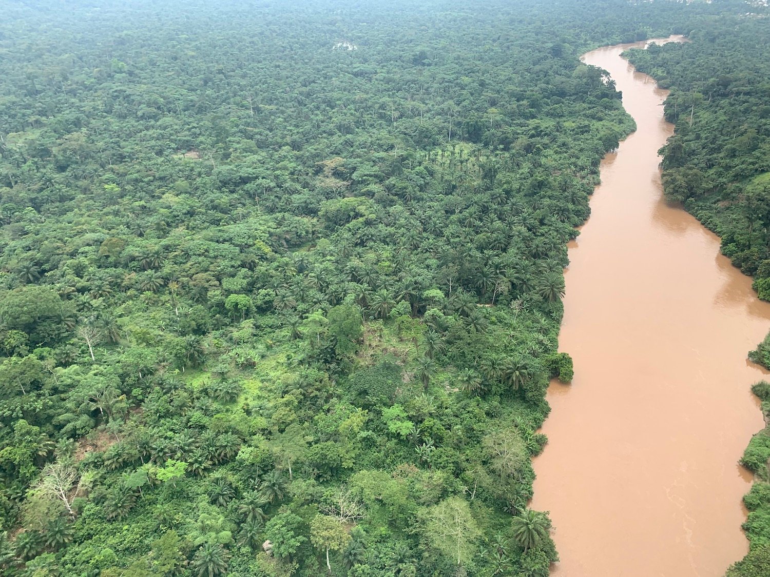
As our expedition headed west towards the reserve, we heard chimpanzees, and recorded their feeding remains and trail well outside the official limits of the reserve. We entered the reserve and spent two days walking the steep mountains (1500-1800 meters), river gorges and valleys (1000-1200 meters). My own observations, supplemented by several expeditions that have already been conducted by Tayna staff, indicate that the majority of the reserve is covered in primary montane forest with a relatively clear understory. The region is characterized by river gorges and steep valleys rich in herbaceous growth, ideal habitat for gorilla. There are an approximate 15 villages (most with 20-30 people) in or bordering on the reserve; these villages practice snare hunting of porcupine, wild rat, and monkey, while maintaining small agricultural fields (hunting rifles and shotguns have been successfully banned since 1998). Community development programs offering alternatives to hunting will first target these villages, and in keeping with Tayna's excellent grass-roots approach, almost all guides and trackers (now receiving salaries as a result of DFGFI's support) reside in these villages. This means that some of the population is now both benefiting from the project and no longer hunting as a means of survival.
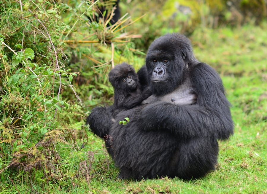
 After walking 5 km beyond the eastern boundary into the reserve, we began to see abundant gorilla trail. In the area we surveyed (about 5 square kilometers) I worked with the Tayna trackers to examine trail signs and locate nest sites. I was able to count two nest sites; one contained 11 individuals, and a second contained 13 individuals. In my interviews with Jean Claude Kayunga, scientific director of Tayna reporting directly to Pierre Kakule, I examined their nest monitoring data for the southern half of the reserve. Given my previous experience tracking western lowland gorillas, I conservatively estimate the southern sector to contain more than 100 gorillas. This southern area only covers about 40 percent of the reserve's surface area, and to the north and west (towards Maiko National Park), in areas that are even more isolated with intact forest, I estimate the presence of at least another 150 gorillas. Thus, at this time, we believe that the reserve contains at least 250 gorillas; chimpanzee distribution is even more widespread than that of gorilla, but densities are unknown. Our biodiversity census, to be conducted in the near future, will give us a truer estimate of distribution and abundance of gorillas. Although it is likely that these gorillas are Grauer's gorilla, it would be premature to rule out the possibility that this form might in some ways be transitional between eastern lowland gorillas and the mountain gorilla forms of the Virungas and Bwindi. The altitude, the mountainous nature of the area, and its very cool and wet climate appear to resemble the Bwindi forest of Uganda, and it is not clear how contiguous this forest is with the lower-altitude forests of the Congo basin (e.g., Maiko National Park).
Reliable informants I interviewed report the presence of forest elephant, okapi, Nile crocodile, and leopard. I observed forest buffalo and duiker trail, as well as visually identifying black and white colobus, red tailed monkey, and a galago pelt. We are also certain of the presence of one other type of monkey and one type of baboon. Other primates may also be present.
As I returned on the same plane, the weather was clear enough to look west and see the mountain ranges near the Tayna Gorilla Reserve. I vowed to return to support this extraordinary community effort to both protect gorillas and preserve biodiversity, and I was proud to be a signatory for the Fossey Fund to support Tayna as primary conservation partner. There is a lesson in this experience for all of us about hope and commitment to conservation. Despite civil war, death, destruction, poverty, and lack of resources, an African community has seen the future and it is a vision of forested mountains in which they can go and experience their natural heritage: okapi, monkeys, duiker, buffalo, elephant, and chimpanzee. Moreover, their conservation effort for future generations has as its icon, the gorilla, largest of primates, a symbol now shared by both the Bamate and Batangi tribes of the Tayna Project and the staff and supporting contributors of the Dian Fossey Gorilla Fund International. With a vision and hope as strong as this, one cannot help but feel the winds of peace in the air.
By P.T. Mehlman, Ph.D.